Monday, August 29, 2011

Dublin to Wales

Friday, August 26.  We got up early to take a taxi to the Ferry Terminal.  We had tickets on the Ulysses, which is cruise-ship size. When launched 10 years ago it was the world’s largest car ferry.


(I had thought I'd visit some of the literary sites in Ireland, but this ship was as close as I came.  I have, however, been reading, James Joyce's collection of short stories, Dubliners; have no intention of ever reading Ulysses, though.)

The Ulysses has six decks for cars, buses, and trucks.  It can carry 1342 cars, 240 trucks and buses, and 2000 passengers and crew.  I couldn't see how the loading/unloading arrangements were configured, but I know it took nearly an hour to unload the vehicles at the other end.  The nice security lady in the parking lot at the other end advised us to wait until the ship had unloaded and avoid the traffic jam.  Here's a view of the Dublin Harbor as we sailed away.


We splurged and got tickets to the club level – “free” snacks, tea and coffee, newspapers, magazines, and wi-fi.  And very uncrowded. (I had visions of crowded bench seats and active, noisy tykes, etc. in steerage, but that turned out not to be the case.)


There were a lot of cars, buses, and trucks (lorries) on board, not a whole lot of us foot passengers.  In just over three hours we had crossed to Holyhead, Wales.  Here's the Irish Sea en route and the Holyhead shore.


We picked up our Hertz car and headed for Betws-y-coed, Wales.  I had picked a Band B there because it wasn’t very far from Holyhead and because I was intrigued by the town’s name.  Here’s how I think it is pronounced:  Buh-TOOSE-uh co-WEED.  The letter w, in Welsh, is pronounced as double-oh. 

Along the way we stopped in the university town of Bangor, primarily looking for an ATM (the machine in the Holyhead terminal not honoring our cards; we'd read that B and Bs prefer cash; will charge extra for plastic).  We got thoroughly lost trying to find a legal place to park near the city centre, but finally got parked and found an ATM where we got some British pounds. Here's a large building at the university, which overlooks down town.


And here are shots of a historic church that we took a look at.


Betws is in the area of Snowdonia National Park, but I hadn’t researched anything about that.  More fun to be surprised than prepared, no? Well, this area is big for mountaineering and other adventure pursuits.  The first big surprise was these mountains along the road to Betws.


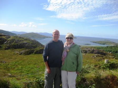
At one scenic turn-out we visited with a couple from Cambridge who had come to Wales for the holiday weekend to escape persistently rainy Cambridge.  Here's their picture of us.  (Now that I think of it, you'd probably be more interested in seeing them than another picture of us.  Will try that next opportunity..)


Then what I thought might be a sleepy farming village turned out to be a jam-packed, hopping mountain-resort town.  Full of stores selling outdoors gear and full of lots of healthy young people - people for hostels, not B and Bs..  The day we arrived, Friday, was the start of a long holiday weekend – the last Monday in August is a bank holiday, something like our Labor Day to mark the end of summer.  Second time we drove through town we found our B-and-B, unloaded, and a little later strolled through town.  Here are some pictures:

A river runs through it.

The village green:


The view from our window:


Saturday we planned to stop at the Bondant Garden, called the most beautiful in Wales and just a short way north from Betws.   The weather was rainy and chilly, though, so we decided to skip the Garden.  Check out the website to see what we missed.

Plan B was the Conwy Castle, a few miles further north.


Weather still rainy, but there was some shelter in the castle and enough gaps in the rain to have a good time exploring.  I climbed the circular staircases to the top of a couple of these towers.


Susie did ground-level exploring.  There she is now!


We then headed east on a four-lane highway, heading almost across the country to York, England.  On the way we exited in search of a good picture of a harbor, but ended up with just lunch.  But, we saw this law office. The firm's name is Griffiths and Hughes.


 Susie has Welsh heritage, father was a Hughes, mother was a Griffith - close enough.

We stayed on motorways and expressways all the way to York.  Had to because we had to bypass Liverpool, Manchester, and Leeds (where they were having a major rock concert for the holiday weekend). GPS did its job.  Seemed like we repeatedly got off and on M1 and one or two other M-roads.  After this, it's back to the minor, more bucolic roads  

Sunday, August 28, 2011

Kenmare to Dublin

Wednesday we left Kenmare.  Have to be in Dublin Thursday evening to catch the Friday morning ferry to Holyhead, Wales.  We decided to go south, then work eastward along the southern coast, catching some of Ireland's 10 most beautiful villages along the way.   Waterford and its crystal were our main objective. 

Before breakfast, when I took some of our bags to the car I saw a nice rainbow arching overhead.  Went back to get my camera and got this much-diminished rainbow.  (You should have seen the one that got away.)


Tried to take a second picture and found my camera’s battery was dead.  So, the only pictures we got this day of driving through spectacularly beautiful countryside and seafront villages were by cell phone, and I can’t extract those to put in the computer and then in Tuziblog.  Hoping to find some internet photos to plug in.

Our first off-the-beaten-path destination was Castletownshend. Along the way we enjoyed driving through Glengarriff, Bantry (where we did some shopping), Ballydehob, and Skibbereen.  The GPS was particularly helpful in getting us through Skibbereen and on to the road to Castletownshend:  turn left, then right; take the third exit from the roundabout, ... .  The town's castle, at the lower right of this internet picture, is now a B&B.


It was lunch time and we found what appeared to be the only eating establishment in the village: Mary Ann's Bar and Restaurant.  But, it was a good one.  There was a poster in the bar featuring 100 Irish Pubs of distinction and Mary Ann's was there.  This is an active fishing village and fresh seafood was a menu feature.  We heard someone ask about prawns, but today's catch was not in yet.  I had a very good crab sandwich, made from local crabs.  Here's an artist's rendering of Mary Ann's.

The GPS lady outdid herself directing us eastward toward the main coastal highway; through very narrow lanes and even when we missed a turn (more than once), the GPS found another path through the labyrinth.  And I do mean path.  Not once did she say, Make a legal U-turn.  There was always a plan B up her sleeve. We passed through some charming little villages and by some elegant country estates, but could never find them again.

Eventually, we got to Kinsale, a coastal resort town just south of Cork (pictures here).  This is on the Top 10 roster and may also be the namesake of the Virginia/Chesapeake Bay village near which Lael and Katherine, my brother and his wife, sometimes reside (for the last couple of years they've mostly been sailing their way around the world).

Here we took an ice cream and latte break on a nice harborfront patio.  Music was playing in the background.  Susie had earlier mentioned that in various places we've been it seemed they were playing American golden oldies, if they weren't playing Irish music.  Still, it was a surprise when, as we were enjoying our break, we heard the strains of Silent Night wafting over us.

En route to Waterford, now late in the afternoon, we got off the highway at Dungarvan.  After wandering aimlessly for a while just sure we would find a hotel or B&B, I turned the job over to the GPS lady.  She took us to St. Anthony's B&B.  The lady owner was enthusiastically friendly, called us Luv, Dear, etc.and the accommodations were just fine.  At her suggestion we ordered in some pizza and had a good night's rest and recharged the camera battery, too.

Thursday morning we drove on to Waterford, wandered around for a while trying to find the Waterford Crystal Visitor Center (Miss GPS tried to take us to a now-closed site in the outskirts of town, but we had been told the new center was in the city centre) and, after two sets of instructions from residents, we finally found it.  Glad we did because it was a fascinating tour.

It starts here, with glass-blowing.


Then proceeds to the cutting.


(Susie said, Who knew that friend Thorne Davis was working here - for those of you who know Thorne.)

Then there are further cleaning, polishing, and inspection steps.  Our guide told us, if I remember correctly, that about 30% of the pieces fail an inspection along the way and have to be crushed and melted and started again.  Also, there are other factories throughout Europe, but here at Waterford is the only place where the specialty sculptures are made.  For example, various sporting events have Waterford Crystal trophies.  Here are some sculptures in process:

For the London Olympics:


A Waterford piano being made just for Justin Timberlake:


The Capitol dome:


This is hard to see, but this is a 9/11 Memorial
:

After Waterford we headed north toward Dublin.  Still quite a bit of time before our five o'clock scheduled return of the car, so we headed for another top 10 village – Gowran - and in search of lunch.  The GPS got us there by the scenic route, but there was no place to eat – maybe one takeaway shop.  There also didn’t seem to be much of charm there either – maybe this large church ruin. 


(We just have village names on a map.  We left the coffee table book of pictures and text home, so we don't know why they were selected; figured it should be obvious, shouldn't it?.) 

Susie spotted this flower garden in front of a house where we turned around, twice, so we took this picture.


And took this picture for the sake of quaintness:


I stopped in a butcher shop and asked them where to eat (smart thinkin', huh.).  They confirmed nothing in Gowran but they came up with an enthusiastic recommendation for a Garden Center restaurant three or four km up the road.  We drove by a/the garden center, but all I saw was a garden center, not a restaurant, so I didn’t turn in.  Susie said I was driving too fast and missed the entrance.  I said, OK we’ll loop back around and I’ll drive real slow and we'll turn in.  In about a quarter of a mile, there was an intersection and I could tell it would take us back to where we had turned and found the garden center.  Circled back and drove by the garden center again very slowly.  AND THERE WAS NO DRIVEWAY to turn in on!  We did see a sign for the restaurant saying turn left at the next intersection, which is just where we had turned left the first time around.  Did it again, but this time we tried an unlabeled driveway that looked like it might go into the back side of the garden center.  And it did.  And it connected with the parking lot in front.  This truly was a garden center with an attached restaurant.  And the meal may have been our best.  I had whiting, nicely battered and with a tartar sauce that was garden-tinted; Susie had turkey and ham with trimmings.


And that excursion to Gowran concluded our Irish backroads adventures.  

Off to Dublin via motorways.  We had a reservation at a Crowne Plaza hotel near the airport.  This was a bargain I happened upon through Expedia.  They have a mystery deal.  You tell them what area you want to be in.  They tell you the best price of a certain level of hotel, say 3-star, but they don’t tell you the name until after you’ve paid – no refunds, either.   Their reasoning is that these high-end places don’t want it to be known that they’re selling rooms so cheaply.  Shh.  Maybe I shouldn't be telling you about this, so keep it mum.  But, of course, the next time it will likely be a different hotel. We got a room for $95; most Dublin hotels websites I looked at were double that or more.
I programmed the GPS for the airport (I didn’t have an address for the hotel, just an area so I hadn't been able to set that goal for the GPS), figuring that we’d see the nearby hotels, but that didn’t work.  Drove around the airport once, then found a place to park and plug in the hotel name (finding a place to pull over and get our bearings has been one of our most daunting tasks.  End up in all sorts of dead-ends, parking lots and the like.)  That worked and we found the Crowne Plaza a couple of miles from the airport.
Next step was to return the car.  Should be easy, I thought.  I found my way back to the airport (without copilot Susie) and looked for signs for the rental car return.  Didn’t see any signs, or any that could be translated to that.  People beeped at me for driving slow while I searched for information.  Made one loop by the terminals and parking garages, but no soap.  Fortunately, as I left that area  I spotted a gas station/convenience store.  The nice clerk there said, Continue down this road to a roundabout, take the third exit and drive down that road.  You’ll see the Car Hire area.  You won’t see any signs until you’re there.
Well, I got in the wrong lane of the roundabout and couldn’t get to the third exit.  By taking the second exit I was about to exit the airport, bound, apparently, for a motorway going down town.  But, I found a break in the traffic and negotiated a u-turn to get back to the roundabout and take the right exit.  Successfully turned the car in.  Apparently no damage from our various bush-brushing and curb-rubbing episodes.
Rental agency van took me to the terminal where I could catch van to the Crowne Plaza, which runs twice an hour.  Found the hotel-bus  pickup area just as a CP van was loading up.  I was last on board, sitting with one cheek on four inches of seat between two large guys.  Better, though, than hailing a taxi or waiting for the next van, I figured. 

And so -

Here's to your roof,
may it be well thatched
And here's to all
under it -
May they be
well matched.

(Irish Toast)


Cheers,

Susie and Rob

Friday, August 26, 2011

Ring of Kerry

Ireland’s most famous, or most popular drive – the Ring of Kerry -  loops around the Iveragh Peninsula on the west end of County Kerry.   Our Rick Steves guide advised that if you’re driving, leave early in the morning and drive clockwise because the tour buses, some of them on a long day trip from Dublin, drive counter-clockwise and are thickest later in the day.  Counter-clockwise also puts you in the oceanside lane from where the view is better and the scenic pull-offs (lay-bys) more convenient.   So, that was the start of our strategy.   However, in order not to make the day too long, we decided to drive to the end of the peninsula, then backtrack to Kenmare.  (I also have the feeling that this late in the summer, mid-week, the bus traffic should be light – and that’s the way it turned out – aren't we the clever travelers?)

[Incidentally, in case I haven't mentioned it, we found the Rich Steves guides to Ireland and to England to be the most useful.  He gives you opinions, not just PR. He prioritizes.  For example, he says there's not much to see at the Blarney Stone castle and why would you want to kiss a rock that is coated with other people's lipstick and spit.]

First stop on the Ring of Kerry was the town of Sneem.  Turned out to be a good place to get Susie some latte and some pastries for both of us.  Enjoyed it so much we did the same on our return trip.  Also bought a load of postcards to send home.  Here are some Sneemscenes.


Continuing along the coast we came across this beachfront Caravan Camp.  Eat your heart out, Tuzigoot.  Didn't look like full hook-ups to us, though.


The next stretch of road took us by what one sign proclaimed as the most popular photo-op on Ireland’s most popular road.  Here’s a shot from that area where we stopped where another couple had stopped and took each others' pictures. 


Also, Susie wanted a picture of these two contented cows nearby.

Got to the busy town of Waterville where we strolled a bit and found a restaurant overlooking the water.  Those are candles in this picture.  


This particular body of water is called Ballinskelligs Bay.  Across the bay is a village called Ballinskelligs and that is our day’s destination because I’ve been reading a book I found in our B and B’s lounge, titled Skelligsside.   The author, Michael Kirby, was born in Ballinskelligs in 1906 and lived there all his life – as a farmer, fisherman, and poet.   His book,  published in 1990, tells about his life, the Skelligside people, customs, and culture.   Made me want to go there and see the magic he felt.

In one section of the book he writes about an early-day poet, Eoghan Rua O’Suilleabhain, who was known as quite a ladies man.  He was also a teacher and the story goes that he took a fancy to the widowed mother of one of his students.  He asked the student to snip a lock of his mother’s hair while she slept and bring it to him.  That would help him win her affections.  The lad told his mother, Teacher wants a lock of your hair.  She clipped some hair from their dog – "a fierce dog of mongrel breed, with a golden-yellow coat” and sent that to school with her son.  Eoghan was sure that was a good sign.  As he approached the widow's house, Kirby says, “his heart was light with expectation as he neared the widow’s house, whistling and singing.  Alas!  If he had no story coming, he had one going away, for the fierce yellow dog tore the trousers off him, and the poet decided that a good run was better than a bad stand.”

So, after lunch, we branched off of the Ring of Kerry to drive over to Ballinskellig.  The village is fronted by a beach and out at water’s edge are the ruins of a castle. 


I took off my shoes and waded across the little creek between the shore and the castle.  Climbed  to the top, got some pictures.

We next proceeded on down the peninsula to essentially land’s end.


 Tthen we looped back to the Ring of Kerry and retraced our route as far as Sneem, for our second Sneembreak.  From there we took a back road through the peninsula’s high country.  Ireland’s tallest mountains are in this range.


Back in Kenmare, we topped off our day and our stay by going to one of the restaurants and pubs featuring traditional Irish music.  We heard Michael O’Brian, playing the small accordion and singing, accompanied by guitarist Sean O’Connor.  (Surely stage names, we said with some cynicism.)  They were very good – O’Brian really works that accordion and also sings a sweet heart-tugging Irish ballad.  Incidentally, have you ever wondered, who invented the accordion and why?  I bought an O'Brian CD, but after looking at the cover and listening to recording, it was apparent that it had been several years ago - before he developed his style.  You know how some Irish songs seem to go on forever.  Well, that's what this CD is like, song after song!


Tomorrow we begin a 2-day trip back to Dublin.  We'll be in touch.

Susie and Rob

Thursday, August 25, 2011

The Beara Peninsula

On Monday we explored the Beara Peninsula, from top to tip.  We started by driving up and over Healy Pass (elevation about 1000 ft.) to go from the north side of the peninsula to the south.  This road was built in 1847, during the Famine, to facilitate the movement of people and goods between the Counties Cork and Kerry.  Here are some scenes on the way up.


"Now, where did I leave my sheep?"


"Oh, there they are."


At the top of the pass (about 1100 ft. elevation) is this crucifixion shrine, erected by an anonymous donor in 1935, restored in 1969.


While we were parked at the top we had a nice visit with a Scottish couple.  I said I imagine that this country looks something like the Scottish highlands and they agreed.

Back down at sea level we continued SW to the colorful town of Castletownbere.


Just after we parked we were walking toward this street from the other end and heard the sound of one car hitting another.  The driver had pulled in toward the curb on the left to park and clipped the right front of a the car she was trying to pull around.  Looked like a case of driving a little too far to the left, but we didn't stick around to see if the driver was a normally right side driver.  Just served to heighten our awareness and a feeling of relief that it hadn't happened to us.

As this is written Thursday night we've completed six days of driving.  No major problems.  Doing a little less bush-whacking on the narrow roads.  Where I goof when instinct takes over is when I try to make a quick click of a turn signal only to turn on the windshield (windscreen, here) wipers.

I will say that having a GPS has been incredibly valuable.  There's no way we could have negotiated ourselves through some of these towns by reading maps and signs without horribly getting lost and making numerous turn-arounds and stop-and-ask-directions episodes.  

On the Castletownbere waterfront:


I took a quick peek at the town's Catholic Church - quite dramatic.


We had lunch nearby and then drove on down to the western tip of the peninsula.  From that point there is an aerial tram that goes to Dursey Island.  I had hoped to ride the tram but its schedule was full -- farmers and residents (there are "about six" the sign said) have precedence.  The tram was hauling hay on this load.


Here are some scenes along our return on the north side of the peninsula.


There are a lot of these solid, two-story plus, rectangular houses in this area.

We took an ice cream break at one little village that looked to be mostly weekend or summer homes - not many people around when we came through.


Susie asked the lady in the shop if people coordinate their house-color choices.  She said, no, they make independent choices, but, of course, with an eye to the colors that would fit in OK.  Everything seems well-painted.

Soon after this stop, at one intersection I made a quick decision, contrary to Susie's good advice, and we ended up on a long loop off the main ring road that got us into some of the narrowest road we've encountered.  At one point, both I and the oncoming driver folded in our side mirrors, shouldered through the roadside shrubbery, and eased past each other.  There was a stretch of 2-3 miles where if we had met a car, one of us would have to back a long way to find a place wide enough to pass.  Fortunately, didn't have to do it.  This road, though, took us buy an interesting cemetery and the ruins of a small church and a host of other great views..


At one point we came upon a young man herding some cattle along the road and into an adjoining pasture.  All the while he was talking on a cell phone.  Whodathunk he would get reception?  Maybe it was a satellite phone. 


A lot of the country lanes are bordered by this orange flower - looks something like a day lily.  Won't scratch your car when you brush against it.


Had a great day, finished it off with a sort of light dinner in Kenmare, and found a laundry where we could drop off some washing in the morning and pick it up that night after we complete our next peninsula drive, The Ring of Kerry.

I'll close with an Irish saying I found:

Top of the morning to you
and the rest of the day to yourself.


Susie and Rob