Tuesday, August 13, 2013

O Canada!

Friday, August 2.  We entered Canada at a Vermont border-crossing.  Tuzigoot got searched and we had background checks run. 


The agents were two pleasant young men.  One asked, What do you do?  I said I'm retired.  Why are you going to Montreal?  To attend a convention.  If you're retired, why do you go to conventions?  Well, I do some occasional teaching.  They were just killing time while we were electronically vetted.

Driving through this part of Quebec from the Vermont border to Montreal was like being back in the Midwest -- mostly flat land with fields of corn and handsome houses and farms.   Miss GPS led us around the city, staying south of the St. Lawrence River, to the Montreal South KOA.  This campground is about 15 miles SW of downtown.


Saturday we took a Gray Line Hop On and Off city tour to see Montreal highlights. 


That's Susie up there in the cap.  Don't hop off!

We hopped off and had lunch in this area where Marc Chagall decorated a street turned promenade with lots of strings of  lots of pink spheres.


We were exposed to art as we drove by the modern art museum.  The artist who created this piece of glass art, titled bad hair day (I just made that up), is Dale Chihuly.


This imposing church is St. Joseph's Oratory (I'm using Anglicized names rather than the French, which is usual in Montreal).


Brother Andre started his religious life as a doorkeeper at the University of Notre Dame, across the street from the hill where this church was ultimately built.  He later came to lead a worship center on that hill and became a widely sought counselor, spiritual advisor, and healer.  His advice to those seeking help was generally, Pray to St. Joseph.  (Mary's over-booked; no waiting for Joseph,  That's how I would summarize it.  Remember the movie, Bruce Almighty?  We watched it on TV one night on the road.  Bruce (Jim Carey) played God for a time and had more prayers to answer than he could cope with.) 

Brother Andre developed such a following that this basilica was built to accommodate it.  It was completed in the 1960s.  Brother Andre died in 1937 at the age of 91.  Over a million people attended his funeral rites, it is said.  He was declared a saint in 2010.

We didn't go into the church because it was late in the day and only one or two more buses would stop here this day.  I came back the next morning (our hopping tickets were good for two days) and went inside.  (The meeting of the American Statistical Association started Sunday afternoon -- geeks and nerds -- so Susie opted to stay at the campground.) 

Sunday services were in progress. 


This sanctuary in a lower level is called the crypt.

Here's the main sanctuary.  Took this picture from the family room, a glassed in room at the back of the cathedral where children can move about and make noise.


Very modern looking.

By way of contrast, here's the Notre Dame Basilica, just a block away from the Convention Center where my meeting was held and where I parked the two days I drove in.  I had wanted to see it Sunday, but was turned away by a guard who asked, service, or just look?   The Gray Line guide told me later, Just say service.  They want you to wait and pay to go in and look.

Early Monday morning, I went in.  Was astounded by the sight!


The colors, the woodwork, the statuary, the sheer size.  Awesome.  I sat for a while just to soak it all in.

The article at the link says that the architect, James O'Donnell, an American, was so overwhelmed by his creation that just before it was completed (in 1879) he converted to Catholicism on his deathbed.  The link also lists the artists who created the interior.

Just down the street I stepped into a small café and deli in search of breakfast.  Was having difficulty ordering because of the language barrier, so the owner told me to sit down.  He'd bring me breakfast.  And a fine one it was: two eggs over easy, potatoes, bacon, toast, jam.  Perfect.  I went back on Tuesday for an encore.
 
Meeting went well - heard some talks that kind of reinforced some of my views of how statistics should be taught.  There were two tribute sessions to statisticians - one who recently died, one who turned 90 and is still going strong - that I have known and been influenced by.  Also, some material to work into the book I'm writing.  Had a productive meeting with a publisher's rep.  The journal I edited, way back in the 80s, has an annual dinner and Susie and I went to that one evening - another chance to see old friends.

One reason we picked the Montreal South KOA was because it was near a train station from which I could commute to downtown.  The train had a limited schedule, though, so I just used it once.  A couple of friendly agents helped me negotiate the ticket machines and find the return train.

On Wednesday, we took a drive along the St. Lawrence River.  Started out with a plan to drive up the south bank, return by the north. After a while it dawned on me that we should have done the opposite.  That way the river would always be on our right, which would make for better viewing and opportunities to pull off. 

In one village the GPS showed me a waterfront park, so we found our way down a little lane to that.  The park featured a tribute to a pioneer woman.  Because the statue was under repair, there was no information about who she was.  Susie called to another person in the park: Do you speak English?  He said he did.  We asked about the pioneer woman.  He didn't know who she was but she had shot some Indians back in pioneer days.  She's toting a rifle up there on her pedestal.


And here's her view of the river.


Not long after this stop we saw a sign for a ferry. Love those car ferries.  We could cross the river and thus continue our trip with the river always on our right.  The way was not well marked, but we found the ferry and took it across the river. 


The landing point was on an island just off the north shore.  We drove around the island, looking for a place for lunch.  In one village two old guys and a school girl told us in a mix of French and English, that it was right up the road, second stop, turn left.  We couldn't find it.  We kept driving on up the river and checked out a couple more villages.  No luck.  Drove through some very nice areas, though, featuring large, gorgeous estates bordering the river.  Finally found some lunch and soon after reached our goal, one of the few bridges across this stretch of the river.  We crossed and headed back toward Montreal.

Oh, the roadside café we found featured six (!) life-size cow heads, animated - their heads swayed back and forth, back and forth, ... .


Coming back we came across this impressive church in Pierreville. 


Most every crossroads and hamlet in the area was named for a Saint.  At last, some respect.


Finding Saint Robert took us off the river road (on the north bank, it's called the King's Road; on the south bank, it's called the Navigator's Route).  I used the GPS to work our way south.  Most of this area is a grid with diagonal roads relative to North-South, East-West.  We zigged and zagged, often on some pretty minor roads, but eventually got home.  GPS is wonderful.  Would never have done this sort of boon-docking before.

Thursday, as we prepared to leave and HEAD HOME the living room slide-out would not retract.  Oh, no!  I went to the office to ask for a reference to an RV repair shop.  The lady on the desk said, I'll call our handyman, Bernard - an employee of the park.  He came over and quickly found that the long bar that the motor turns to move the slide-out was broken - twisted like a pretzel.  Something had jammed the slide-out - I don't recall it sticking and me forcing a closure - and the force of the motor twisted the bar until it broke.  What now?  Bernard said, I think I've got a replacement in my shop.  And he did!  He put the new bar in.  The slide-out wouldn't move.  Bernard went looking and found what looks to be a half-inch piece of a rivet that had broken off and lodged in a bad place.  Now, everything worked.  Best service ever!, I think.

So, we headed west toward Sault Ste. Marie, Ontario, from where we would cross the border into the upper peninsula of Michigan.  Getting out of Montreal was difficult due to construction and traffic.  In hindsight, I realize our GPS is outdated.  Looking at the atlas later, there looked to be a better way.  Live and learn.

If you want to check your Ontario map, our route was highway 17.  We started counting the miles and deciding when we wanted to get home.  The only particular goal is to make a stop in Denver to see son Jeff and family.  On day two of this trek had probably our longest day - 375 miles.  That got us to a KOA in S.S. Marie.  One of the best parks we've been in.  The owner couple is a former USAF Thunderbird pilot and his wife, a champion dog trainer.  One service they offered was to weigh your motor home. (They'll also help train your dog.)  Knowing its weight and how it is distributed over the six tires is important for safety and reliability.  I've read articles about the importance of knowing your motor home's weight, but never had Tuzi weighed.  Thought about it often as we drove by truck weighing stations, but wasn't sure they would weigh us.  Just relied on the assumption that Allegro and Michelin had us set up properly.  The weighing showed we were within limits, though a little unbalanced, left vs. right.  (That's not a political statement.) 

Crossing the bridge into Michigan, USA, was very slow. 

 
Here's where Lakes Superior and Huron connect.  The word, sault, means rapids or falls.


The Border!

My copilot.

Once we got to the Customs agent, he just had a few questions and we were good to go.  Which reminds me: the day before we had stopped at a roadside stand and bought some fruit and vegetables.  While chatting with the KOA owner, the subject of border crossing came up and he asked if we had fruit or vegetables.  Oh, oh.  He said, those will probably be confiscated, if they ask.  Susie said, Could we leave the food with you?  He said, OK.  He had an employee who was in a tight situation and could use the food.  So, that's what we did.

Next stop: a campground on Lake Michigamme where we stayed once before, several years ago.

Susie and Rob

Friday, August 09, 2013

New Hampshire

En route to Montreal, we spent two nights in mid- New Hampshire, at a KOA near Woodstock.  It was almost deja vu all over again.  Soon after we set up, there was a knock at the door.  Young man asked me to go over to the office - there was a mix-up in site assignments.  We were in site 2; manager thought she assigned me to site 1 and had subsequently sent somebody else to 2.  However, she realized her mistake and re-assigned the second party.  The next night, though, might be a problem.  Site 2 had been reserved to someone who had requested that site and we had been assigned it for two nights.  But, she thought she could take care of the problem without moving us.  And, she did.  However, we spent the whole next day traveling this part of the state and were not available, just in case.

First, here's the Pemigewasset River as it flows past our campground.


We drove east from the nearby ski resort town of Lincoln, through the White Mountains.  Main destination was Mount Washington, home to what is proudly claimed as the worst weather in the world. Here are a couple of mountain scenes along the way.


There was a legend posted here about a young woman who had been swept down these falls and disappeared.  Her companions tried desperately to find her and couldn't.  They worked for hours to divert the river so they could better continue their search.  One of the searchers plunged into a pool, felt a hand, and pulled.  There was an answering squeeze on his hand.  Somehow the woman survived, perhaps because the frigid water preserved her cryogenically.  As this is written I can't find my notes on this story, but if I find them, I will update you.
 
 
Mount Washington is known for having the world's worst weather, strong wind in particular.  Back in the 80s for several summers I came to a conference in NH.  I did some exploring in the lake region south of here, but there wasn't time available to make a trip to Mount Washington.  It's been on my bucket list, so now was the opportunity.
 
There are three motorized choices to get to the top: drive yourself, ride up in a van with a guide, or cog railroad.  I opted for the guided trip.  This would give me more opportunity to see the sights and not have to worry about the narrow road with severe drop-offs and no guard rails.  Because Susie doesn't do well with heights and drop-offs, no matter who is driving, she elected to stay below.
 
Here is a picture on the way up. 


On this day clouds moved on and off the peak. 
 
The cog rail train arrives - an engine and one car.   

 
This building is the office and gift shop of the van line.  Note the chains that anchor the building to the mountain to keep it, the building, from blowing away.

 
Still the record high wind speed observed by man. The gage broke before the storm was over, so who knows if even a higher wind speed was observed? 


There were some hilarious videos playing in the visitor's center that showed people and things being blown around.  One guy was trying to pour a glass of milk, but the milk streamed off horizontally.
 
Our guide, Eric, told us that there is a waiting list of meteorologists for government job openings on top.  Also, a waiting list to be the Weather Channel’s reporter on Mt. Washington.  The weather station is staffed year round (provisioned by snow-cats in the winter)

Successful summiteers.


Had to take my own picture.
 
Mt. Washington is one of three presidential peaks in this range.  The other two being Jefferson and Madison (check?).  MW was named for George, however, before he was elected.

 The road project was started in 1853 and the road opened to carriage travel in 1861. The first automobile to the top was in 1899.


They have races to the top: running, biking, driving.  The road has an overall grade of 12.5% - one mile of elevation gain for eight miles of road.  The record for a car is just over six minutes– unbelievable.  I asked about accidents or fatalities.  None on the road (well, maybe some scrapes), but no incidents of a car going off the road and plunging down the mountainside.  There have been injuries and fatalities of hikers on the mountain.
 
On Eric's recommendation we stopped at a nearby waterfall.
 
 
Our White Mountains loop (they were named this because the mica schist rock on the mountain has a white sheen) continued north, then west, then south to dinner in North Woodstock, then camp (and no request to move).  A nice day in the mountains.

Susie and Rob


Cape Cod

We arrived at our campground in E. Falmouth, in the west end of Cape Cod on Friday (July 26) afternoon and set up - twice.  The lady that checked us in told us our site was B62 and mapped out how to get there.  When we did, I saw the site was labeled B62-T and there was a pop-up trailer parked there.  The next spot was labeled what looked from the road to be B62.  So, we backed in - very carefully, this is a tightly laid-out park and mostly the dreaded back-in sites.  We lowered the jacks, opened the slide-outs, connected water and electricity, and settled in.  Phone rang.  Front desk was calling to see what site we were in.  I said B62.  She said, you're supposed to be in B61.  I looked at my receipt and it said B61.  I checked our site sign and it said B63 - the bottom of the 3 was partially obscured so that I mistook it for a 2 from the road.  The lady up front said, we'll try to see if we can switch reservations around, but if we can't, would you mind moving?  We'll send someone to help you.  By the time he got there, I had surveyed B61 and it was a more level site than B63, so we decided to make the move and save management the trouble of having to juggle the reservations.  All went smoothly.  Here's our lovely site - this is a very nice campground, except for, as we've found almost everywhere, very poor to non-existent wifi.


Saturday we drove to Provincetown, at the end of the Cape - around 65 miles from our location.  Along the way we took a few random detours through "Thickly Settled" and magnificent residential areas.  There is a lot of weekend traffic on the Cape, so some of the trip was stop and go. Mostly stop.  I was ready to turn back, but Susie urged me onward.  Glad we persevered.  A pleasant lunch stop restored our spirits.
 
Not long before Provincetown I saw a sign for a lighthouse.  Turned off and found our way there.  (This is known as trip planning.)  Ach!  It was the Cape Cod (Highland) Lighthouse.  (Officially, it's the Cape Cod Lighthouse; it's known locally as the Highland Lighthouse because the terrain resembles the Scottish Highlands, including the golf course that adjoins it.) 

The lighthouse, originally built in 1797, is on a bluff 174 ft. above sea level.  A quote from a Rev. Levi Whitman, 1794, was posted in the little museum that said, "That mountain of clay in Truro seems to have been erected in the midst of sand hills by the God of Nature for the foundation of a lighthouse, which, if it should be obtained, in time no doubt would save the lives of thousands."  A historian speaking on a video said that there were probably 3000-5000 wrecks off of this coast, so it was a dangerous place. WARNING: Ships Use Caution.  Land may be nearer than it appears. 


The current structure was built in 1857.  The ocean continually eroded that mountain of clay so that by1990, the lighthouse that was built 500 ft. back from ocean's edge was only 128 ft. from it.  By this time technology had rendered lighthouses obsolete, but the area's residents felt it was important to preserve this bit of history.  They raised money and got governmental support and in 1996 the 430 ton structure was moved, on rails, 453 ft. further back.  (Statistics problem for the reader: When will the lighthouse need to be moved again?  Provide error bars.)  The Coast Guard operates the light, so the lighthouse is still doing its duty.

 I (Susie says she doesn't have to do every crazy thing I do) climbed the stairway – a mere 69 steps that turned out to be a warm-up for a bigger challenge to come.  Here’s the view from the top:  ocean and golf course.


We drove on out toward land’s end in search of a beach and picked one among several.  Got my feet wet in the Atlantic Ocean.


From there we drove in to Provincetown.  Our goal was the Pilgrim Monument, which the guide at the lighthouse had pointed out to us across the bay separating the lighthouse from Provincetown. (Nice pictures at the link.)  I didn’t know this before this trip, but the Pilgrims landed first on this part of Cape Cod.  They explored, found fresh water, and stayed a short while before moving on to Plymouth, near the base of the cape.  Here's a map for reference.


The streets were narrow and crowded.  I couldn’t find a way to the monument.  Turned, at one point, to return to the road leading out of town and happened upon a sign pointing the way to the Monument and parking.  Eureka!  

At the base of the tower is an interesting museum about Provincetown and the Pilgrims.  After storms kept them from their planned Virginia destination, the Pilgrims (Wikipedia is my source) landed here on Nov 11, 1620, and right away established rules for governance, the Mayflower Compact.   Most everyone stayed on board the Mayflower through the winter, while others scouted for a better site, finally selecting what became Plymouth.  The settlers disembarked there in March, 1621.  Just about half of the settlers and crew had survived the journey. 

 Here's the monument - 252 ft. high. 
 
 
I climbed the ramps and stairs to the lookout platform just below the apex, which I unfortunately didn't get in the picture.
 
Looking down at the way up:


I don't know how many ramp and stair "squares" it took to get to the top.
 
Some views from the top:


I'm waving at Susie who is in the pickup down there in the parking lot - a dark red blob, backed up against the trees, in line with the left end of the tennis court, next to a white blob.


Sunday we went to a West Falmouth Methodist church.  Nice service but hot and sticky in the sanctuary.  As you leave the parking lot a sign says, You are now entering the mission field.  Nice reminder.  Sunday evening we met Vijay Nair, our friend from U. Michigan who is the chairman of the helmet committee, for dinner in Woods Hole. 

The committee met Monday and Tuesday at the National Academy of Science's Jonsson Center in Woods Hole.  Rather than summarize I'll just copy and paste its history from the the website.

 In 1884, James Marshall, a stockbroker who lived and worked in New York City, and who had summered at the Quissett Harbor Hotel in Woods Hole Massachusetts, purchased property on the harbor on which to build a summer cottage for his family. After completing the estate which included the Carriage House and a sizable dwelling (now the Wheeler House) and enjoying 8 summers in that house, the family desired a larger, more formal residence. The original house was moved at the end of the summer season in 1906 by workers using wench horses and an earthen ramp to a location on a hill opposite Quissett Avenue slightly to the right of the drive as you exit the Center. This was a challenging feat for the day and made more exacting by the fact that it was moved with the furniture, family belongings and stone chimneys intact.

The new house was a replica of the earlier one, with enlarged rooms, the addition of the rear porch and rooms above, formalized fireplaces, added servant's quarters and pantries, and many decorative and ornamental features. Completed in just 11 months, the residence was ready when the family arrived the following July. A remarkable accomplishment, but made possible by the availability of the ships carpenters in surplus as a result of the fading whaling industry and the resulting reduced ship building.

The Marshall's had three children, two girls and a boy. In time the ownership of the house passed to one of the Marshall's daughters, who sold it in 1934 to Mr. Hobart Ames of Boston. Again it passed to the heirs, who in turn sold it to Mr. Howard Houston. In 1975, the National Academy of Sciences purchased the house from Mr. Houston to use as a site for holding meetings of the Academy and the National Research Council during the late spring, summer, and early fall months.

 Preservation and restoration efforts have been accomplished gradually and are ongoing. As projects of any magnitude have been identified, great authentic reproduction, and identical or superior quality materials are specified in order to ensure the architectural integrity of the structures.

 Here's a picture copied from the website:
 

  My picture of the view looking out:

 
The bathrooms are still in the (com)mode of when this was a residence.  I don't think any of our committee members took a bath during breaks in our deliberations.

 
My meeting was Monday and Tuesday.  We left Wednesday, headed for Montreal. Next report: Woodstock, NH.

Susie and Rob

Sunday, August 04, 2013

Massachusetts

Loose Ends.

Here are youtube links to my favorite bluegrass groups at the Grey Fox Festival:

Dry Branch Fire Squad

I Draw Slow

Gibson Brothers

And, we've been getting twin grandson pictures from Heidi along the way.


Aaaaaahhhhh!  The latest video features them putting plastic buckets over their heads and bouncing around a room like pinballs. 

Bluegrass done.  Back to business.  Headed for Cape Cod and a two-day committee meeting.  This committee deals with test plans for military helmets.

From Earlton, NY, we drove about halfway across Mass. to Sturbridge where we spent four days at a Jellystone Park campground.  We took the MassTurnpike, I-90, that connects Albany and Boston.  It's pretty much a tree tunnel, which gave me time to think about road signs.

As you approach bridges in MA, rather than those flip-up[/down Bridge Freezes Before Roadway signs I've discussed, the sign says Plows Use Caution.  This means, I think, that if it snows enough to freeze over on the bridges, snow plows will be out plowing the bridges, so use caution as you approach them.  Trouble is, the signs are right at the bridge.  If you haven't seen the snow plow before you see the sign, it may be too late.  So, the second meaning of the sign must be a warning for snow plow drivers: You watch out for oncoming cars.

As this is written we're in Montreal.  Quebec has the best sign yet for icy bridges.  No ambiguous words.  There's a drawing of a skidding car.  Next to it is a large thermometer showing 0 deg. C.  'Be careful if it is cold enough for the bridge to freeze' is the clear message. The highway authorities assume you know enough that if it's freezing outside the bridge could be hazardous.  Of course, how do you know how cold it is as you drive along?  Hmmm.  Maybe the previous bridge was icy.  Or, snow plows are out.

Another interesting MA sign that appears in residential areas is Thickly Settled.  You might be inclined to think that that applies to the whole state.  But, from the interstate, except at exits, you'd think it's all woods.  Only occasionally do you see farms or towns.  Also, strict laws on billboards means you have no clue what's beneath or behind those trees.  Can you believe it?  I'm missing the CLINES CORNERS AHEAD signs.

We took one day trip from Sturbridge to drive to Springfield and see the Basketball Hall of Fame.  We drove the regular US and state highways with a loop through Connecticut just to enjoy being off  the interstate and seeing where people live and work.  Primarily, as discussed, we've been sticking to the interstates on this trip, which is often not our first choice.  I think the low clearance episode a few weeks back has got me a little gun-shy over driving Tuzigoot on these secondary roads.  But, we've generally been staying a few days at most of our stops, so that provides the opportunity to see what you can't see from the interstates.

 The Basketball Hall of Fame looks like a basketball.


And, of course, that's a basketball at the top of the tower.

The ground level of the round-ball has basketball courts, with mostly kids playing, then there are a couple of floors of exhibits ringing the inside of the sphere. 

Here is James Naismith who started it all when he nailed the peach basket on the balcony at the YMCA in Springfield.


I compared my wingspan to Kevin Durant's.  Should have stepped closer to the camera.


And, here's my basketball hero, Hall of Famer Coach Hank Iba of Oklahoma A andM which became Oklahoma State University.


As an undergraduate at OSU I used to enjoy stopping by Gallagher Hall and watching the basketball practices.  Listening to him instruct and correct the players was fascinating.

Coming home we managed to find an ice cream shop.


Across the street was an antique shop called Rustology.  Should have been called Dustology.  Here's a mannequin on a snowmobile that caught my eye.  Think she was waiting for her ice cream cone.


Old Sturbridge Village, in Sturbridge, is a recreated 1830s village with role-playing guides.  When we were there, there was also a role-playing summer camp group of kids and counselors.


We heard a vintage organ played and discussed in the village church.


OSV had a large area of lawn at the entrance filled with flags, a Field of Flags, recognizing members of the military.  We added a flag in recognition of grandson, Tony Hinkle, who recently completed three years of Army duty, including a tour in Iraq.  Here's his proud grandmother.


One last Sturbridge picture.  Jellystone only had wifi at the office, so I spent some time in the Sturbridge library.  Avery place in and out.


Next stop: Cape Cod

Susie and Rob

Monday, July 29, 2013

New York

Wow!  Just realized our last post was no. 300!.  Is that all? I can imagine some readers muttering.  Seems like more.

Sunday morning, July 14.  We (Mandi, Paul, and we two-zi) drove from our campground down to Hyde Park, the village that is home to Franklin Roosevelt's home, Springwood.  He was born here and is buried here.  It was his favorite place to be.  His presidential library - he was the first to have one - and a newly refurbished museum are also located here.  The museum has many displays and videos that tell the story of the Great Depression and FDR's programs to overcome it.  And, they describe his life before the presidency.

I didn't know the story of his polio. He contracted it in 1921, when he was 39 years old and active in NY and national politics - he had been the Democratic candidate for VP in 1920!  One evening at the family vacation retreat on Campobello Island in Canada, he complained of chills and fatigue.  Two days later he was paralyzed from the waist down.  He struggled mightily to cope with and overcome the effects of the disease - Eleanor cited it as his greatest demonstration of courage - and resumed his active political life. He was elected governor of NY in 1928 and of course, President, in 1932. 

Our museum tour was cut short by the start of the home tour.  I found out later that there were two other floors in the museum that I had not gotten to.  So, if you're ever in the area, check it out and send me a report.

We had a good guide for the home tour.  Several of his anecdotes pertained to FDR's mother, Sarah Delano.  She lived at Springwood with Franklin and Eleanor for many years after her husband's death and pretty well ran things.  As a result Eleanor never felt at home there.  At one point during FDR's presidency the king and queen of England were en route to Hyde Park for a visit.  Franklin had a collection of political cartoons, several of which, critical of England and the royal family, were prominently displayed in the foyer.  Mom told Franklin to take them down.  Somehow, that didn't happen.  The royals arrived.  The K espied the cartoons and went over to take a closer look.  After a while, he turned to FDR and said, I see you've got a few that I don't have.  No offense taken.

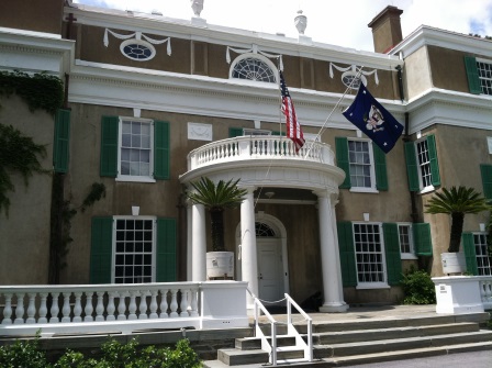
Here's a picture of the house.


There are two wings on either end of the house, not shown, that Franklin had added at some point.  The upgrade improved the facilities from two bathrooms to 15, or so.  The White House-like portico was an FDR addition before he became president, so maybe that was a clue to his ambition.

Oh, look who just came out those doors:


It's Paul and Mandi!  The Venable First Couple!  (FDR and Eleanor were the Venerable First Couple.)

Here's Roosevelt's grave site, backed by an impressive-looking carriage house.


(Technical detail.  I complained earlier about Blogger not uploading pictures.  Among the suggested remedies I found, one was to change your browser.  I switched from Firefox to Explorer and that took care of the problem.)

After a late lunch we went a short ways up the river to tour the Vanderbilt mansion.  This stretch of the Hudson was known as millionaires row because of the estates that lined it - Astors, Vanderbilts, Roosevelts, Rockefellers, ... .  The Vanderbilt who built here was Frederick.  His mansion is not as grandiose (excessively so, IMHO) as that of his brother, George's, in Ashville, NC - the largest home in America - but it's still pretty impressive.

Here's the exterior of the Vanderbilt home facing the river.  Nicely understated.

 
And here's the view.


It's interesting: these homes were generally just occupied by their owners in spring and fall.  Hot and humid here today, Monday, as this is written, so summer was not a good time.  You've probably seen headlines about the East Coast heat wave right now.  Weather news from home, though, is that the summer rainy season is in full swing.  That's a relief.  The neighbors are still reporting bear sightings, though.

Paul and Mandi headed back to the city on Monday.  Because no campground is complete without ants, they left us a couple.


Big-uns!

On Wednesday we moved only about 40 miles north to a campground near Earlton, NY, which is only about 15 miles from the site of the very big Grey Fox Bluegrass Festival which occurs, very handily, this weekend.  This is another hilltop campground.  After we turned off the highway, we started up a hill on a road better than the one once traveled before, but still eerily reminiscent.  I sensed tenseness to my right.  How do you come up with these campgrounds, Susie asked.  I said this is the closest one to Grey Fox. I'd seen pictures and knew we didn't want to camp on the festival site - pictures below.  The Earlton Hill campground turned out to be substantially nicer than the previous disaster.  Plenty of power for A/C, primarily. It's mostly year-round sites either owned or leased, with just a few slots for traveling-through folks.  That seems to be the pattern here: park your camping trailer in one site for the year or season.  Visit on weekends and holidays.  There are not many transients, like us, and we do not meet many RVs on the roads and highways.

Wednesday afternoon we went looking for the festival site.  Turned out not to be as easy as you would think – not very well signed. We stopped and asked directions a couple of times.  Finally, at one intersection we’d seen before, Susie said, I see a bunch of cars over there.  Let’s look.  Lo and behold, we had found the site.

We had tentatively planned that one or both of us could shuttle back and forth between our campground and the festival.  I can do 8-12 hrs. of unrelenting bluegrass; Susie can’t.  Driving time and parking issues made that option a no-go.  Looking at the schedule, we decided I’d come on Friday, Susie might come with me on Saturday; maybe we’d both come again for the Sunday morning gospel set.

 I went early on Friday to stake out a good site for my lawn chair.  Lawn chair strategery is an important festival skill.  Well, the whole hillside was covered with lawn chairs (set up on Thursday, the first day of the festival).  The rule here was that you could claim your lawn chair spot on Thursday and leave your chair there all weekend.  At Westcliffe, CO, where we generally go in July for their bluegrass festival, you’re supposed to remove your chairs each night, then line up the next morning to grab the best spot you can.  Sort of like an Oklahoma land rush.  Very democratic.  In either case you can sit in an unoccupied lawn chair, but be ready to move, graciously, when the owner shows up.  Very civilized.

At Grey Fox there were more rules.  Some areas were designated only for ground-sitting and low-rider chairs, some for regular size lawn chairs, some were OK for umbrellas, etc. Way in the back you could put up your own shades.  With the anticipated heat already evident, I decided not to try to find a spot out in the open, near the stage.  Way back up the hill there were a couple of tents.  I got lucky and found an opening in the front row of shaded seats and plopped my chair down. 

Here's the view from the tent.


The stage is between those two speaker towers left of center.

After the music started it was apparent that the hundreds, maybe thousands, of chairs out in the open were not going to be occupied.  I picked out a chair in a prime location near the stage and sat down.  A couple came along and asked if it was OK to sit in other people’s lawn chairs.  I said, Sure, I am.  I didn’t last long there, though, with the heat.  Really miserable, even with a broad-brimmed hat.  So, it was back to the tent.  Fortunately, the sound system was good.  Here's my view.


The stage is left-center, between those two speaker towers.

 The band that hosts and helps organize this festival is the same one that hosts the Westcliffe festival – the Dry Branch Fire Squad.  The two festivals are just a week apart.  About 12 years ago the group leader, Ron Thomason, moved to Westcliffe.  Wasn't long before he organized a festival there to raise money for the local clinic.  The Westcliffe festival is big, but not Grey Fox size.  Westcliffe has a tent large enough to cover most of the audience.

In addition to Dry Branch, I was especially happy to see that a group from Ireland, that I "discovered" at last Fall's bluegrass convention and festival in Nashville, was appearing here.  I Draw Slow, they call themselves.  Also, the Gibson Brothers who are an upstate NY band that have a lot of recent success in the bluegrass world.

Fortunately, I Draw Slow, on Friday (the day I was there, not when they drive slow) was appearing on one of the satellite stages, tent-covered.  It was a great set.  They acknowledged that appearing last fall in Nashville had gotten them noticed by the Grey Fox organizers, so here they wer

Back at the main venue, a chap sat down in a lawn chair next to me - in the main stage's covered area.  Said, Where's my other chair?  I said I don't know.  This space was vacant when I got here and placed my chair.  Could tell he didn't believe me.  His second chair was a couple of rows back.  Fortunately, by the time his wife showed up, another settler on our front row had left, taking chair, so he was able to put his chairs side by side.

Then, in mid-afternoon, the sun was hitting the first row, where I sat.  There was an open spot just behind me, so I moved my chair there.  Unfortunately, as I was setting the chair down, it bumped against the man's hand next to me - but I didn't know it.  As I settled in, he was shaking his hand very visibly, showing great pain.  I said, Did I hit your hand?  Sorry.  He just kept shaking his hand and scowling.  It wasn't long until I folded my chair and left for the other venues.

Anyhow, after a mere 12 hours on site, the heat and humidity and the bluegrass had me staggering.  Decided not to come back on Saturday just to see second sets by the above three groups.  Would wait until Sunday and Susie and I would come for Dry Branch's traditional gospel music set.  Some people will be amazed that I would skip a day of bluegrass, but there you have it.

For about a couple of weeks we've been skirting the Catskill Mountains.  Friday we drove a loop through those mountains.  Friday turned out cloudy and cooler, but I had no regrets about taking a day off from Grey Fox bluegrass.  Had some CDs.  Here are some scenes along the way.


Next week, Massachusetts.

Susie and Rob