Our first Tuzigoot outing of 2012, and first such outing since last July, was a trip with our Zia Allegro motor home club to Benson, AZ. Benson is in SE AZ, near Tombstone. Our 'rallymasters,' Norbert and Patsy Baca, picked a very nice RV park, unique in that it has its own observatory -- 16 in. scope, computer-driven, dome-topped. More on that later.
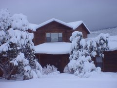
We've had snow in our driveway since December, still icy next to the garage doors, soggy elsewhere, so we decided not to drive Tuzi home to de-winterieze, check things out after her lengthy storage, and load. Instead the strategy was to park a night at the KOA in Albq the day before departure and do those things. We're only going for five days, so one or two trips from home to KOA ought to suffice. Didn't quite work out that way. (Those of you who perversely enjoy hearing about our Tuzi-problems won't have long to wait.)
On Tuesday morning, when I got ready to drive out of our storage lot on Kirtland AFB, I discovered the turn signals didn't work. I was towing the PT, so I drove over to my RV service guy with the hazard lights flashing on the PT. Luckily, no problems or patrolmen were encountered. along the way.
Tom's ace repairman couldn't find the problem so he sent me to a specialist near downtown, to which I again drove, west on I-40, with the PT flashers on. Traffic was light, no lane-change problems, no highway patrolmen to pull me over. That shop determined the problem was a failed multi-function switch. They could get one overnight. It was around 2 pm on Wednesday, departure day, when they called and said they had installed the new switch and that solved the problem. On Tuesday I had taken a load of clothes and other provisions to Tuzi. We took the rest, drove to town, hitched up, and were on the way out of town about three. Our goal was an RV park in the village of Elephant Butte, only three hours away, where we would meet two others of our party.
We got to EB about 6 and I de-winterized and connected Tuzi to city water -- no leaks or problems! The water heater worked; the furnaces worked. I've never left home so unprepared and untested, but we were lucky. Oh, it was fairly windy as we drove and we have a vent fan cover that won't close tightly, so when it's really windy I have to climb up on the roof and duct tape the thing down. Near Los Lunas I pulled over and did the duct tape thing. Routine maintenance.
(One of our traveling companions had a hard-to-diagnose water system problem that delayed their departure to even later than ours. Turned out to be an upside down water filter (usually they're reversible). Who knew? Their motor home is plumbed like ours, so I'll try to remember that quirk. Stay tuned.)
Here's our lineup at Elephant Butt(e). Note that, appropriately, I took the shot from the rear.

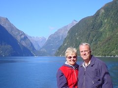
And here's Elephant Butte Lake at sunrise.

The drive to Benson went smoothly -- about 4.5 hrs. Was another windy day, but the duct tape held.
Saturday, Susie and I took a drive on a scenic loop south of Willcox - about 30 miles east of Benson on I-10. The highlight was a visit to Chiricahua National Monument. The low-light happened on I-10 on the way over. All of a sudden, Susie said, What's that on the road? A large object of some sort. I swerved halfway onto the shoulder to get by. As we neared, then passed, I saw that it was a coyote - alive, but he had been hit in his rear legs and couldn't move. His head was upright and his front half looked normal, maybe even defiant, as he faced the oncoming traffic. We avoided him, but who knows how long it was until he was hit? Bad way to go.
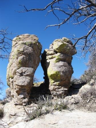
The Chiricahua Nat. Monument is called a 'wonderland of rocks' - all sorts of spires and balanced rocks - remnants of volcanic ash spread over this area millions of years ago. For a good collection of pictures, go here. Here are a few of my shots.


Much of the National Monument burned in a forest fire last spring, but no buildings were destroyed. In Albq and Cedar Crest we were most aware of the fires further north in east central AZ that sent a lot of smoke into our area, and we hadn't known about this fire.

The day concluded with a fine fajita dinner prepared by Patsy and Norbert with trimmings from the rest of us. (There are six rigs and one couple per rig in our group.) Here, Susie instructs some of the group in sign language.

After dinner I went to the evening sky show at the observatory -- these are held every night, conditions permitting. There were about 15 of us, sitting in the dark in a circle around the telescope. The speaker would line the scope up on various features and tell us about them, then we'd all take a look through the eyepiece, one by one. We looked at some moon craters, Jupiter, and some of the stars in Orion.

Early Greek astronomers identified and named the constellations by which we identify various clusters and formations and I've always been amazed at their creativeness and imagination. I wondered if early astronomers elsewhere, such as China, came up with anything similar. Well, wouldn't you know, I found an on-line table and article addressing that very issue. For example, what we call Orion's belt, the Chinese called Three Stars. Duh! See the link for much more.
Benson is on a main RR line - some 60 trains a day we were told. Seemed like a lot of them were at night. Our astronomy guide said different engineers have signature horn blasts. He claimed one of them has an ex-wife living here and he serenades her by blasting the horn all the way through town.
I went out early one morning to get a train picture. Inadvertently had my camera set on video, so this is what I got.
Waited a while for another train, but it was cold so I didn't stay too long. Had to settle for this sunrise-on-the-rails shot.

Saturday morning I went off on my own to take a guided ATV ride out of Tombstone (I had seen a brochure on this Th. evening and decided it looked like fun, others in our group recommended it, so I signed up.)
Went early to look around Tombstone. Here's the Cochise County courthouse.

There were three ATVs in this group and four people in addition to me: the leader, Jim (Apache ATV Tours), a couple from Tucson and their young son.

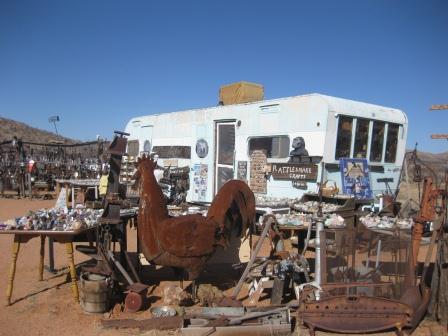
Our trip took us about 15 miles east of Tombstone to the mining ghost town of Gleeson, with a side trip to see Jim and Sandy's Rattlesnake Crafts and Rocks (visited once upon a time by the Today show! a sign informed us). There's an old house trailer there filled with all sorts of things made of rattlesnake hides, including neckties. More amazing was the acre of "primitive and Western antiques, collectibles, and odd items" all displayed out of doors in the dry AZ air. I couldn't stop taking pictures.


Y'all come back, now!
Jim and Sandy, who live in another interesting trailer, weren't there, probably off collecting somewhere, but their shop is open for business on the honor system. Check out their website. It says they left Rockford, IL for AZ in 1979 and traded the work-a-day world for the "laid-back and somewhat lazy lifestyle of rattlesnake hunters."
Gleeson was a mining hotspot in the 1890s and some mining was done there up until 1958. A couple of pictures:

Silver, gold, and copper were mined from that hill back there. The last mine closed in 1958.

Our trip was all on roads, about 25 miles dirt, 10 miles pavement, so I didn't get to experience off-road ATV driving. But, what we did was fun and I'd like to try it off-road some day. We spread out in order to avoid each others dust and I generally brought up the rear. I'd go slow for a while, then speed to catch up doing a little fishtailing and shoulder driving for fun.
After we got back to Tombstone - it was a two-hr. RT - I drove back to Gleeson to get some more pictures, then drove up the east side of the range on what is called the Ghost Town Trail. A couple pictures on that stretch.


My objective was the Cochise Stronghold. These rugged mountains, the Dragoon Mountains, are where Cochise and his tribe holed up and launched raids in the late 1800s. He was buried here somewhere, but the grave and his remains have not been found.

One thing that struck me during the two days that we drove around this desolate, searingly hot (in the summer) area is how many abodes there are dotted here and there among the mesquite trees and cacti. Some are nice homes; some are small shacks and decrepit mobile homes. A lot are empty. You get the impression that people were drawn by the sheer majestic emptiness of the place, and maybe the price was right, but found that actually living here was too hard a thing to do, so they moved on, or maybe died and their heirs wanted nothing to do with the place. Kinda sad. Here's one young lady who didn't leave.

I tend to notice road signs and two days of driving provided good opportunity. They tell you something about how a state thinks about itself. For example, the AZ state highways have frequent Adopt a Highway signs, almost all of which (that I saw) say Available -- lots of orphan roads out there awaiting adoption.
Also, it seems like almost every little dip in the road has a sign: Do Not Enter When Flooded. I suspect the rare event of a flood brings people out to gawk and they have to be warned not to celebrate too enthusiastically.
Then, on the back roads you see these signs: Cattle Guard. Bicyclers Use Caution. Good advice. However, I think just Cattle Guard would suffice. Maybe some unfortunate bicycler crashed on one and sued the state. Now they can't say they weren't warned.
The trip home went fine. We got an early start so made it all the way to Albuquerque, about 400 miles, most of it interstate highways. Took us a while to find a station selling diesel in Deming, NM, but when we did it was the cheapest we'd seen: $3.89.
The only issue was where to go when we got to Albq. Could go to KOA, could go to Cedar Crest and park on the side of our road, rather than the driveway. We chose to go to our storage lot on Kirtland Base. We unloaded everything into the Explorer. Planned to winterize Tuzi, which means pumping anti-freeze into the pipes, but I couldn't get the pump to inhale the anti-freeze. Fortunately, no freeze was anticipated Sunday night so we came on home. I'll think about winterizing tomorrow. Oh, we saw signs of a mouse in the house (Tuzigoot), so we stopped in Socorro and got some mouse traps. We set those. I went out today, Monday, to drain the water and check the traps. No mice, so maybe we just had a visitor who has now departed.
It was a fine weekend -- I haven't mentioned it yet, but high temps in mid-70s. Really glad we went.
Next planned Tuzi-trip is to Las Vegas in May to help with Heidi and Joey's twin boys, due to be born that month.
Cheers,
Susie and Rob