Monday p.m. we just relaxed. Tuesday we visited the Land Between the Lakes National Recreation Area with a side trip to Murray, KY.
On the way to LBL (as it's abbreviated) we stopped in Cadiz, KY, birthplace of Elizabeth Anthony (whose husband, Allen, you met in our Kentucky Bend posting). Cadiz is pronounced K.D.'s, as in something belonging to Miss Lang. We strolled through some antique shops in this scenic town and had lunch.
The big annual event in Cadiz is a fall Hog Festival. You can buy a t-shirt advertizing the (fictional) Ham Hock Cafe. They've expanded the hog theme to painted pig statues all through town. That may be a Hog parked in front of those two pigs, too.
Two parallel rivers, the Tennessee and the Cumberland, run north through TN and KY and empty into the Ohio River. The "land between the rivers" became the Land Between the Lakes when both rivers were dammed to provide hydroelectric power, flood prevention, and shipping along the TN River. Then, in 1963 President Kennedy declared the LBL region to be a National Recreation Area. This meant that the farmers and other residents had to be relocated. The Wikipedia LBL site indicates that not everyone was happy about that. It wasn't like their land was going to be covered by a lake. The government just wanted to use the land for other purposes.
The main visitor center is at Golden Pond, site of a former town. Just behind the dogwood you can glimpse the pond.
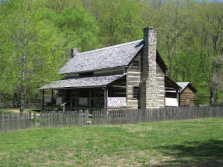
At one of the visitor centers I was looking at a detailed LBL map and noticed a lot of cemeteries. Driving through the LBL we had seen several side-roads going to cemeteries. I asked how many cemeteries? About 270. Around 5000 families were moved; their homes and a few small villages were razed. There is still farming, though, in cleared areas. The cemeteries are the lone connection of residents and descendants to the land of their families. Now there are buffalo and elk and other wildlife, lots of hiking trails, a few campgrounds, and a recreated 1850s homestead. Here are some scenes from "The Homeplace."
This gentleman is preparing to plant cotton.
This shapely scarecrow is scaring the crows away from the garden.
After LBL we drove about 20 miles SW to the town of Murray. This is the home town of friend, Pat Young, formerly Cedar Crest, now of Bastrop, TX. We talked to her earlier in the week and she encouraged us to see Murray. We took a turn by the Murray State U campus.
On the way down town, though, Susie said, "There's a Mexican restaurant. Let's go have a chips and salsa snack." (It was mid-afternoon.) We did, and it was good. We've been gone just over a week. Could we/Susie be having salsa-withdrawal symptoms already? A few blocks later, we found an ice cream place. What a day!
Back at Prizer Point, caught the sunset. We had seen signs that the LBL rangers were doing controlled burns and in fact had to reverse our course once when we found a road closed in a fire area. The ashes in the sky helped add color to the sunset.
Next stop: Mammoth Cave.
Cheers,
Susie and Rob


No comments:
Post a Comment