Next day we headed west on Canada Highway 3. Long day, about 250 miles, up and over several mountain ranges, dramatic changes in terrain. Had lunch in resort town of Osoyoos which is in Canada's desert -- actually an extension of the Sonoran desert.

Our destination was Hope. Found our RV park in a grove of tall trees tucked, naturally, between a freeway and a RR track. Susie said she got no sleep the first night because of the train traffic. Second night OK, though.
The spot we were assigned was next to the playground near the campground entrance. Park map showed lots of sites back among the trees. I asked: Any of these sites available and large enough that we could fit into? One was and the person on desk said you can drive back there and check it out. She said I could do it without unhooking. Well, that was almost a very big mistake. With tight corners, low overhanging branches, and lots of brush we managed to circle through the park, rubbing up against some small branches, but fortunately no scratches that I didn't think were already there. Our potential site in the trees would have been impossible to get into so we settled for the slot up front.

Later in Vancouver I talked to a guy who had led an RV group on a trip that included a stop at Hope. He said they picked another RV park in the area because of the problems in ours.
We spent two nights in Hope and had a day to look around the area. Hope is surrounded by tall, steep, forested mountains and is located on the Fraser River, named for Simon Fraser, who, in 1808, worked his way down this river headed for the Pacific Ocean, thinking he was on the Columbia River (upon which Lewis and Clark had traveled a couple of years earlier). Wikipedia says Fraser's exploration of this area was one reason that after the war of 1812 the U.S./Canadian border was set at just south of the mouth of the Fraser River, which is where Vancouver is located.
Fraser had a lot of difficulty getting down the river - steep canyon walls, raging rapids. He characterized one area as the gates of Hell, now a tourist attraction called Hell's Gate where you can take a tram down to and over this site, which I did.


The river is not particularly wide at this point - in fact its narrowness was what made it hell to get through -
but it's very deep: 150 ft., I believe. That means that the volume of water flowing through it is twice that of Niagara Falls!
There are two railroads running through Fraser Canyon: the Canadian Northern and the Canadian Pacific, one on each side of the river. I hung around at the bottom long enough to catch this train going through.

Hope is known as a center for wood carvers and many works adorn the streets and parks. Here's a sampling.


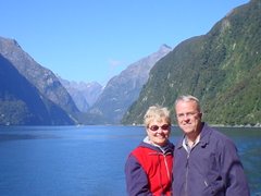
Portrait of a tourist.
Then there was this pole dancer in downtown Hope.

Cheers,
Susie and Rob


No comments:
Post a Comment