Monday, June 22, 2009

One More Farm Day

Sunday, the plan was to take Jeff and Valerie’s boat to one of the nearby lakes for some cruising. A steady rain in the morning changed our plans. Instead we took a 2-3 hr. drive through the countryside. Still saw lots of water, though. They’ve had a lot of spring rain, resulting in floods so there’s a lot of standing water and numerous closed roads.


A main attraction on our tour was the Sand Lake National Wildlife Refuge. An awful lot of waterfowl migrate through South Dakota. Highlight at Sand Lake was a 108 ft. tall lookout tower. I climbed it -- 132 steps. Here's a picture looking up.


And here's a picture looking down. That's Susie between the tower and Jeff's pick-up.


This land is very flat in this part of the state, so water doesn’t drain; it just stands and slowly seeps away, but not quickly enough to offset successive rains.


Also, this is primarily corn-growing land, but there are many fewer farms (houses and barns) per acre than you see in IL and IA. The population density in SD is 10 people per square mile, compared to 15 in NM, which we think is pretty sparsely populated. Iowa has 15 people per square mile.


Valerie (whose job as a juvenile justice system officer requires a lot of travel around this part of the state) had seen a sign out in the country for the Granary Rural Cultural Center so we checked that out. Sign said open every day, but all that was open was the sculpture garden and the 'Dakota Walk' that winds through it. A couple of buildings housing an art gallery and a gift shop weren't. Only Valerie and I were up for Rural Culture. We kind of got the idea of the Center from what we could see, but the above website defines it:


The Granary is strongly dedicated to nurture the creative abilities and artistic expression of youth. We aim to generate an active constituency to celebrate the work of local artists, make fine art a part of community life, and advocate strong Fine Arts programs in high school education.


Here's a piece of sculpture. What do you think it means?


The jumbled up columns, it was explained, represent people not working together, different agendas, etc. The lined-up upright columns represent people working together to make something useful and pleasing to the eye.


A case in point, cited in a plaque at the Center, was the battle in the 70s and 80s over the Oahe Irrigation Project. A grassroots group of unlikely allies fought off a big government project that would have caused a major disruption of the state's water and land systems (one part of the plan was to channelize the James River near Aberdeen to provide better drainage). You can read about it the above Oahe website.


One other piece of sculpture celebrated RFD.

I think this earnest fellow was a little upset because the Sears catalog was late.


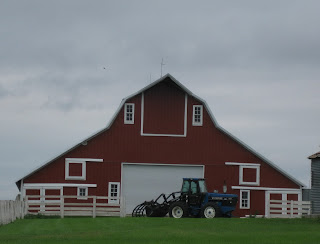
Jeff also braked for barns, at my request. Some choice examples.


Topped off the day with more walleye. Good food all the time. Had a great time with Jeff and Valerie. We're leaving tomorrow, Monday, for points north and west. Stay tuned.


Cheers,


Susie and Rob

Saturday, June 20, 2009

Farm Days

Friday, June 19. Life on the farm.


Here are Jeff and Valerie with their miniature horses. They've got eight of them.


With a chick-chick here, and a baa-baa there, and a neigh-neigh here, and arf-arf there, ... . They've also got chickens, goats, dogs, and a cat.

And, here's a shot of the farm that Jeff took earlier in the spring, I believe. They have 18 acres. Nice sheds and barns for the livestock and toys. But, the winters .... !#@$$@%


I played farmhand for an afternoon, driving the John Deere and mowing one of the pastures.

Before all this, though, we went to town to visit Jeff's Shop-Ko store, and to do our Wal-Mart (pardon the expression, Jeff) sort of provisioning at Shop-Ko. Then it was lunch downtown, not far from the county courthouse.


Saturday morning we we to Aberdeen's Arts in the Park arts and craft show. Susie went for high art: a plaque saying "I laughed so hard that tears ran down my legs." We all had deep-fried cheese curd -- very tasty.


Incidentally, folks from Aberdeen are known as Aberdonians.


The afternoon got even more gastronomic. Jeff deep-fried walleye for the first appetizer. Next were incredibly hot chile poppers prepared in Jeff and Valerie's smoker. The main-course ribs and pheasant were in the smoker all afternoon.


Final act was a gorgeous sunset.


Cheers,


Susie and Rob

Thursday, June 18, 2009

SPAM!

We camped Tuesday night at a KOA between Austin and Albert Lea, in SE Minnesota, setting up during a light to moderate rain.


The campground information sheet listed things to see and do in the area, one of which was to visit the SPAM Museum in Austin. I've seen that museum listed on unusual museums to see lists, so we decided to check it out Wednesday morning. It's great! Colorful, informative, and free samples, too. And FREE admission. Guaranteed to give you several smiles. This website provides traveler reviews. Here's a Warhol tribute I found on the internet.


As you can see, the spam we're talking about is canned meat, not junk e-mail (and why did that come to be called 'spam?' Case of slander?). Some call it the mystery meat, but one thing you learn is that there is no mystery about the meat content. It's all pork, "primarily" pork shoulder meat (oh, but what about secondary pork parts?). Then, there's sugar, salt, and other spices. The ground-up ingredients are put in the cans, sealed, then cooked for 2.5 hrs., and shipped.


The production volume is awesome, especially to those of us who identify SPAM with our youth and rarely consume it now: 7.8 million hogs were converted into SPAM in 2000. Two production plants can produce 44,000 cans per hour. Three cans per second are consumed in the United States. The state with the highest SPAM-use per capita is Hawaii. Korea is a major foreign consumer.


SPAM was invented in 1937 by the Hormel folks in Austin, MN. It gained fame for its ubiquitousness in WWII. You can watch film of soldiers talking about SPAM two or three times per day. A grainy newsreel, SPAM Goes to War, tells you that SPAM went to Europe before the troops -- as a major ingredient of the Lend Lease program in which the U.S. sent food and aid to Europe prior to our entry into the war. "From Oklahoma to Okinawa, SPAM was there," intones the narrator. Makes you want to salute.

My SPAM memory of more recent vintage is a float trip down the Grand Canyon that Roy Sooter and I made in the early 70s. Our outfitter served SPAM once a day, every day. Either fried for breakfast or in sandwiches for lunch. Backpack trips that I went on back in that era also generally included a can of SPAM.

Other museum highlights: The SPAM-ettes quartet singing, Mr. SPAM-man, bring me some food, ... .


George Burns and Gracie Allen were sponsored by SPAM.


Bet you're getting hungry for a can of SPAM right now.


The museum features a short, entertaining movie and lots of colorful, informative displays.


There were quite a few people in the museum on a Wednesday morning, including a red-hat ladies group.

So, if you're ever in the Austin, MN vicinity, go see the SPAM museum.


Right across from the museum is Johnny's Main Event restaurant, featuring a SPAM-A-RAMA. menu. Had to go there, of course. I had SPAM and eggs; Susie had pancakes, just a bite of my SPAM.


Then it was back to Lake KOA. We checked out and headed west.

Ended up in Pipestone, MN, for the night. Nice campground, 30 miles or so off the beaten paths of interstate highways. Here's the evening's sunset.


Later that evening, Susie said, Did you hear the news. One or more tornadoes just hit Austin, Minnesota. Earlier in the evening the TV had shown Pipestone to be in a tornado watch area. The campground flyer said that in case of bad weather, drive to a downtown store with a basement. To be ready, I went out and disconnected the PT. The night went by quietly.


Thursday morning early it's raining lightly. Susie says, the TV says this area is in a severe weather warning area all day. The map shows, though, that across the border west and to the north in South Dakota, no problem. So, we hustle away. So far, our timing has been good (lucky).

Now, late afternoon, we're on Jeff and Valerie's farm, southeast of Aberdeen, and the TV is saying, severe thunderstorms approaching Aberdeen. Gotta stop watching local TV! An hour or so later, here's the approaching storm.


Earlier, while fleeing Pipestone, going north toward Lake Benton, all of a sudden we were in a region of glacial hills -- green, rolling, very scenic. Didn't stop for a picture, but found a good approximation later on the internet:


Also, west of Lake Benton is a large collection of electricity-producing windmills -- 600 plus windmills, I find out later, and more being built -- we saw a couple of trucks hauling those big blades. Lake Benton proudly calls itself the "Original Wind Power Capital of the Midwest."

Meanwhile, back on the farm, we only got brief period of wind and rain as the thunderstorm line moved over us.
We'll be here through the weekend.
Cheers,
Susie and Rob


Tuesday, June 16, 2009

Cassville Ferry

Tuesday. We decided to make our last Mississippi crossing a big-un -- a toll ferry departing from Cassville, WI. The ferry's website said it could take semis and RVs. Trusting the Garmin GPS (which for some reason has lost his/her voices), we worked our way north from Mount Carroll into Wisconsin (noting, as we passed through, that Galena, IL looks like a town you might want to spend some time in). However, when Garmin started us down a road with a CAUTION - Bridge Out 10 miles ahead sign, it was oh-oh. Very fortunately, just after I turned there was an industrial building with a parking lot and two driveways that enabled us first, to pull in and consult the map, and second, to decide where next, and third, to change course.

Decided we could return to the highway we had been on, continue a few miles further north, then come back to the SW to reach the ferry via Hwy. 81. We found the 81 turn-off and wound our way through a mid-size town, then encountered another Bridge Out sign. Oh, no. But there were also signs indicating there was a Hwy. 81 West Detour route that would presumably get you around the missing bridge. According to the map, Hwy 81 would dead-end at the Ferry, so I figured they wouldn't be directing people on to Hwy. 81 West Detour if you couldn't take it all the way to the end. So, with undaunted courage, we dutifully followed the Detour signs. Seemed to take forever, lots of hills and curves winding among classic Wisconsin dairy farms, but, finally, there it was: Cassville itself, right on the river bank, and signs directing the way to the ferry.


When we pulled up to the waiting area, no one else was there, but we could see the ferry chugging up the river. Instructions said if the ferry is not here, turn on a light attached to the little toll house and the ferry will come and get you. We get the impression that the ferry is not a major connecting route between Wisconsin and Iowa. I turned on the light and sure enough, the ferry returned.


The ferry docked and discharged its eastbound passengers.


Hmm, how long is this trip going to be?

Some history: The first governor of Wisconsin came from Cassville and the town was once a competitor to become the state capital. In more recent times the town had pushed to have a bridge to Iowa constructed, but when that failed to happen, they refurbished the ferry.


Now, it's our time to cross. By this time one other car had arrived. I talked to the ferry attendant (if I can call him that) and found that I would need to disconnect the PT, so I did. He laid out some large planks that would get me onto the ferry without scraping Tuzi's rear end on the ramp and carefully guided me on first. Then came Susie and the PT and then the other car. It was occupied by a friendly retired couple from Iowa, just out exploring the country.


The Iowa terminus was about a mile upstream. This power plant is on the Wisconsin side. It's powered by coal from Wyoming and Montana. Trains (and I remember seeing these in Wyoming) bring the coal to Dubuque and it is then off-loaded onto barges and shipped up here.


You can barely see the coal pile to the left of the power plant. Our guide told us that it would get considerably larger as the plant stockpiled coal for winter, when the river would be iced up. He also told us about another plant on the river which is powered by burning RR ties. So that's what they do with old ties.


For you techies, here's a picture showing how the ferry reverses directions: the boat that propels the ferry is attached to the car platform by an arm and the boat just pivots around.


On the Iowa side, the route away from the river is a narrow dirt road twisting between corn fields for about a mile until you reach pavement again. We suspect that the ferry is more a tourist thing than a business or farm-to-market enterprise. Our guide was a retired guy, essentially doing this as a hobby and an excuse to spend time on the river. Said the company can't hire anybody, even students during the summer. Too much weekend work, he said.


A few more miles up the road we pulled off on an overlook for a last view and fond farewell to the Mighty Mississippi. There are houses on that island out there.


I programmed Clear Lake, IA into the GPS and let Garmin tell us how to get there. Oops, we're told to turn off Hwy. 13 and when we do we're greeted by a sign saying a bridge ahead has 5 ton limit. That'll never do. We pull into a (fortuitously located) Dollar General parking lot and ask a store clerk whether we should proceed. Turns out that the bridge is on a side road, so we can proceed.


As the afternoon goes on, it starts to rain. We had planned to stay in an Iowa state park, but that's looking less attractive. We decide to head for a KOA near Albert Lea, Minnesota -- our fourth state of the day! It rains pretty heavily the last hour of our trek. Been a pretty long day - about 300 miles and various delays and complications. Susie asks if the Cassville Ferry was worth it. I say Yes.


Cheers,


Susie and Rob

Monday, June 15, 2009

Carroll County Barns

Sunday evening and Monday morning I drove the country roads around here in search of barns. Here's a sampling.


Thought the John Deere trailers at either side set this one off nicely.


I espied an oblong barn that was in pretty bad shape, but not far away I saw its sturdier twin. Had to drive about a quarter-mile off the road along the edge of a corn field to get the picture, but this barn's architecture seems pretty unusual.


Most of the 'impressive' barns I saw, in size and style, were showing neglect. Guess they served their purpose so fresh paint and lumber are not being expended on their behalf. Pity. Kind of like retired statisticians. Need to get some of those historic preservationists interested in barns! Get some "bale-out" money and fix them up. I'd volunteer to swing a paintbrush.


Which reminds me of a story I meant to tell you about Butler, MO. I mentioned I painted the Cross family barn to impress Judy's father. I had to pass muster by both of her parents. When Judy said I planned to be a statistician, her mother replied, with a frown, "Well, you know what I think about statistics." No respect. We don't get no respect.

Cheers,

Rob and Susie

Mount Carroll

Quiet day at the Timber Lake Campground today, Monday. All the weekenders left yesterday and the seasonal group also is mostly gone, back to work in Chicago, Dubuque, or wherever. When Matt and family lived in Grand Rapids we often parked at a campground on the outskirts of town. There were quite a few locals who packed the kids, pets, tents, and campers and spent the weekend at essentially their neighborhood campground. Swimming, campfires, etc., just like a real vacation but without the driving hassle. Nobody ever said, "Are we there yet?"


We picked Kaci up at noon and drove into Mount Carroll for lunch (about five miles from Timber Lake). Had a nice visit - she's really enjoying the summer, even though there's NOTHING HERE - in Mount Carroll, pop. 1800. Thirty miles to a Target or Wal-Mart; more seriously, one hour to a hospital. She was up until 2:00 am after yesterday's show, tearing down the Grease set and putting up the set for the next show -- pretty complicated set, I guess. She's on the wardrobe team this week, which means she and others were driving to nearby towns with thrift shops this afternoon in search of appropriate costumes for upcoming shows. That's show biz -- one day you're a star; the next you're doing wardrobe.


After we took Kaci back to Timber Lake we returned to spend some quality time in Mount Carroll. Doing the Chamber of Commerce's bidding, "Come experience Mount Carroll's historic grace, scenic beauty and country charm."


On the south side of town there is a very nice college campus -- red brick buildings, green lawns, lots of trees -- the prototypical small midwest college, at least that's what it appears to be. Turns out that Shimer College was founded here in 1853. It was one of the smallest liberal arts college, enrollment 150, and one with a Great Books curriculum. But, it moved away 30 years ago. Here's the Wikipedia short history:

Shimer was founded in 1853 in Mount Carroll, Illinois, by Frances Wood Shimer and Cinderella Gregory as a non-denominational all girls seminary. In the early 1960s, Shimer gained national attention with a Time magazine article about the school highlighting its reputation as a counterculture mecca. The article cited a survey by the Harvard Educational Review that ranked Shimer as among the top eleven small liberal arts colleges in the United States, along with Carleton College, Reed College, and Swarthmore College. Mounting debts and bankruptcy forced the college to leave its Mount Carroll campus and move to the northern Chicago suburb of Waukegan, Illinois in the winter of 1978-79.

On January 19, 2006, amid controversy, the
Board of Trustees announced that it had accepted an invitation to move Shimer College to the Illinois Institute of Technology campus in Chicago. The move was completed August 10, 2006.


I don't know what happened, but I can't imagine this being a counterculture center for very long.


For the last 29 years the campus has been the site of the Campbell Center for historic preservation studies, which sounds interesting. Their clientele is mid-career professionals in the business of collections care and historic preservation. Many campus buildings appeared to us to be not in use, but the campus is neat and well-maintained and must be successfully filling a need.


The town has several brick streets and many elegant houses on leafy lots. Here's a shot of downtown. Brick-making was a key industry in the town's founding.


And here's a Civil War monument on the courthouse square.

I'm sorry, though, the courthouse doesn't compare well with those we've shown you earlier, so no picture. It looks like three buildings stuck together that don't quite match.

After our sightseeing turn we found a tea shoppe and had some very good pie and cobbler, each a dollar and a quarter! What a deal.


Cheers,

Susie and Rob

Grease!

Susie here.


When I was a star struck girl in college and singing in a couple of musicals, I dreamed of performing on Broadway some day. Well, I soon became a college graduate who fulfilled every girl’s (in the 50’s) dream and received her Mrs. degree and married the man of my dreams. Thus, began the development of the Manny and Susie Hinkle family tree. The grandchildren came along and filled in the family tree. Each family brought great pride and provided wonderful memories for us. Each grandchild developed his/her own special talent, which brings us to the memorable experiences we had yesterday at Timber Lake Resort.


Our granddaughter, Kaci Hinkle, (who has chosen Kaci Scott as her stage name) is employed by this resort for the summer. She was “Sandy” in the musical “Grease” that has had a 10 day run in the theatre at this resort. All these college students who have come from all over the United States were so outstanding and the sold out audiences have been enchanted. As we watched, clapped and, yes, shed a tear or two, we were so proud of Kaci as well as each cast member.


Kaci is not only blessed with a wonderful talent and amazing singing voice, but she is blessed with a family who adores her and has supported her throughout high school and college as she as set her sights on her musical career. None have been more supportive than her parents, Suzy and Matt, who have provided help with high school productions, provided emotional support and, yes, mucho dollars for her singing and dancing lessons and her college education at Baldwin Wallace Music Conservatory in Berea, Ohio, (suburb of Cleveland). Her parents, maternal grandparents and brother came from New Mexico and Texas for her “Grease” performance, as did we. This is such a wonderful opportunity for Kaci as she is majoring in musical theatre and, yes, hopes to perform on Broadway after graduation in two years. We will return in July to watch her performance in “Dirty Rotten Scoundrels”.


As I have watched these gifted performers I realize that God has a plan for each of us. He saved me from absolute rejection and embarrassment if I ever thought that I had any semblance of talent needed to be on Broadway. But—isn’t that what life is about—receiving the God-given talent that is ours and going with it? My talent was obviously not on the stage, but is it O.K. if I dream a little as I watch my beautiful granddaughter fulfill the dream for both of us? We know that God is watching over our Kaci and will direct her in the right path to pursue her dream.


Now, Rob. I'm ba-a-a-ck:

We got to Timber Lake late Sunday morning, got set up, then found Kaci for a short visit.
The Sunday matinee was the last show of the run. Most of you probably know the Grease plot, but just in case:

Good girl Sandy and greaser Danny fell in love over the summer. But when they unexpectedly discover they're now in the same high school, will they be able to rekindle their romance?


Lots of teen-age emotions and fun music and dancing.


The movie starred Olivia Newton-John as Sandy and John Travolta as Danny.
Here, the Timber Lake Danny and Sandy sign autographs.


And here is Timber Lake itself.


The campground is on one side of this little lake. The theatre on the other side.

Getting here was interesting. We trusted Garmin GPS all the way. We drove through lots of gorgeous corn and dairy country like this, no hints of timber or lakes, the road dwindling in size and apparent traffic, no signs giving any indication that we were in a theatre district.


Then, we came to a wooded intersection and there it was! A real oasis. The campground has about 200 camping spots, well-shaded and separated. There are lots of seasonal sites for people who come year after year and stay all summer, plus sites for short-term RVers like us. We'll be here two nights, then start heading west and north.

Cheers,

Susie and Rob


Saturday, June 13, 2009

Mississippi Bridges

Saturday, we decide to wind our way from Hannibal, MO to Davenport, IA, by crossing the Mississippi at each bridge along the way. Sort of like lacing up a shoe. Because typically there are not places to pull over for a photo opportunity, Susie is the photographer today, shooting on the fly. So, here we go. Bridges are identified by the larger town on either end.


1. Hannibal, MO. (Update. In summarizing our Mark Twain activities yesterday I forgot to say that we stayed at the Mark Twain Campground adjacent to the Mark Twain Cave.)


You can see that it's another cloudy day. No rain, though, and temperatures still cool, low 70s at the max. Also, they managed to make this bridge's superstructure look squat rather than soaring.

2. Quincy, IL. Now, here's soaring.


3. Keokuk, IA. The adjacent RR bridge, which you can barely see, is more interesting than the highway bridge.


4. Fort Mason, IA


A bit of a story here. As you approach this bridge a sign says, Limit 8 tons; No semis. We're considerably over 8 tons. Fortunately, there's a large graveled area at the side of the road, so we pull off, turn around, and stop. As I'm studying the map and deciding where-now, a man in a pick-up who has been parked in this area drives alongside. He says, Do you need to cross here? We say, Not really; besides, we weigh more than 8 tons. He says, You can do it. I just saw two Greyhounds go across. They do it all the time. So, we decide to do it. (Who you gonna believe at a time like this?)


It becomes clear that the bridge is plenty sturdy (you wouldn't be reading this if it wasn't). BUT, there are two little zigzag areas that require a long vehicle, like a semi or a big RV, to go out of their lane in order to make the Z without scraping the side. We get extremely lucky and in both cases there is no oncoming traffic. Whew!


5. Burlington, IA


As you can see, this picture is taken as we are heading down an off-ramp. I was headed for an Iowa Visitor's Center and possibly lunch. The Visitor's Center was advertized as Major, or Full-Service, or some such characterization to let you know it's pretty special. We're going to be crossing IA next week, so this looks like a good time for brochure harvesting.


This exit is right down town and as I follow the VC signs, I soon make a left turn toward the river front. Oops. Should have looked before committing myself to the turn. The street is blocked about a half-block down. Burlington is preparing for their riverboat festival this coming week, so there are barricades all along the river front. The only way to get out of this dead-end is to unhitch the PT (oh, the shame of it all) and execute a turn-around -- there is room for that.


I have abandoned thought of the Visitor's Center or lunch and just want to escape, but as we're preparing to re-hitch, a guy comes out of a restaurant and says you can park where you are if you'd like, for a while, and go to the Visitor's Center. We opt to go to the restaurant for lunch. That provided a welcome opportunity to relax. After lunch, I get this picture of the graceful Burlington bridge. Iowa brochures will have to wait. Of course, with the internet, brochures are not such an essential research tool any more.


After Burlington, the route up the Illinois side of the river is the one I'm most concerned about. The roads are shaded on the map to indicate they are paved, but they're pretty dim, apparently county roads, not red or blue highways. But they do have little green dots indicating they are scenic roads, so I figure they might be tourist-friendly. These roads turn out just fine, and the route is marked by Great River Road signs, so it's easy to follow. (I hadn't tried to program the GPS, either from bridge to bridge or for the whole itinerary. We're roughing it.)


6. Muscatine, IA


We cross for the last time at Muscatine and then it's just a short drive to Davenport where we find a very nice RV park for the night. Only trouble is we're in trees and can't get satellite TV; there's no cable; and I can't get the TV antenna/digital converter connection to work like it did at home. So, a quiet evening for reading and blogging.

Cheers,

Susie and Rob